Several weeks ago I went on a field trip to the central part of Oregon. It was a wonderful trip where I found lots of insects, and almost doubled my collection. Here's a few pictures from the trip that I thought you all might enjoy!
 |
| Fort Rock as we approach it. It lies in an ancient lake bed from the time of the Ice Age right after Noah's Flood. |
 |
| Part of Fort Rock up close. |
 |
| Another rock in a line of rocks; Fort Rock being the largest, and at the end. They were caused by a crack in the ground where lava came out, and created this ridge. But because there was a lake here at the time, it cause a steam explosion, and that's why there are only certain parts of it left. |
 |
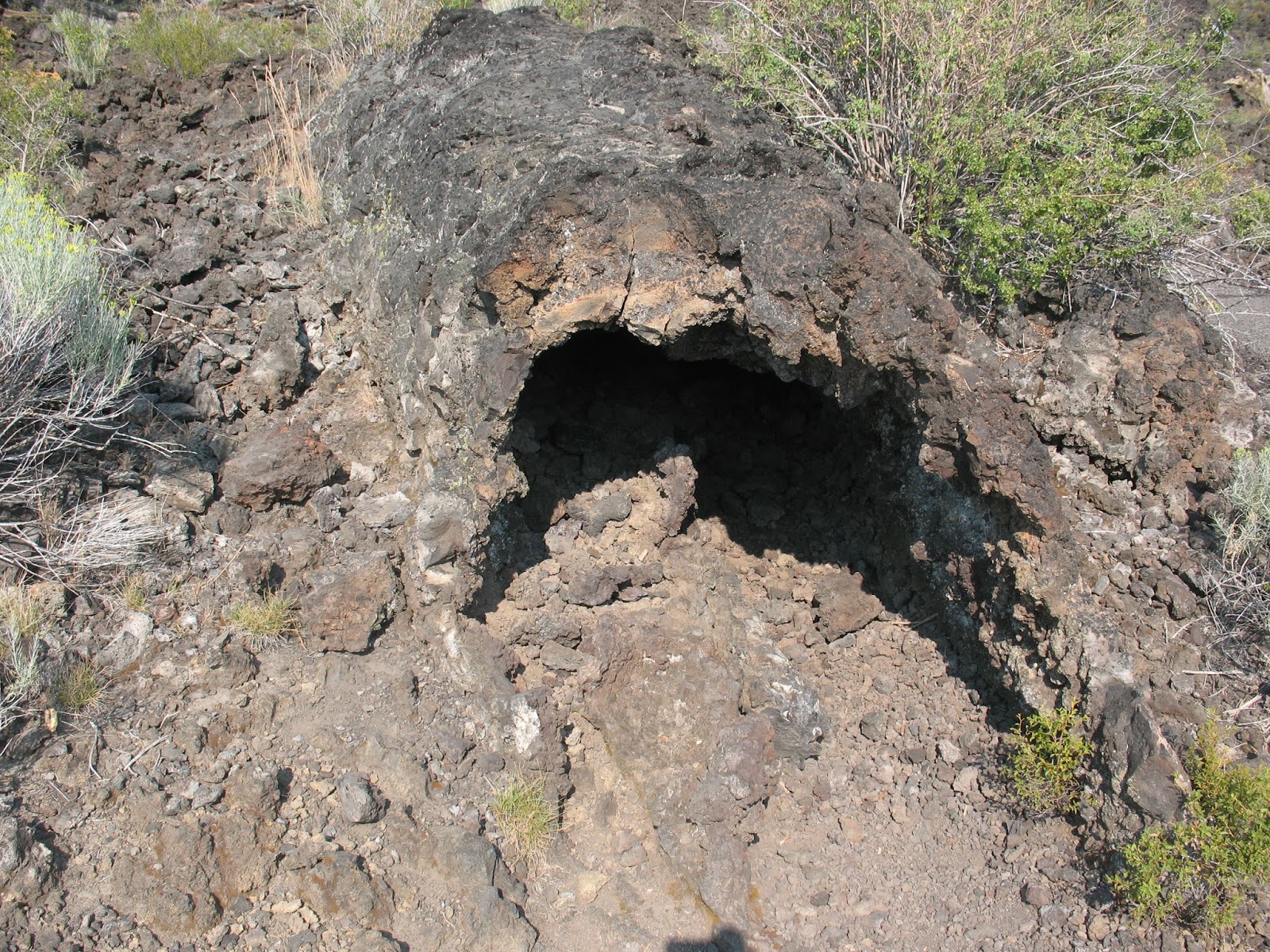
| Fort Rock Cave or Cow Cave. I prefer the latter, as this cave is not at Fort Rock, but the rock close by. Lusser Cressman in 1938 found ancient human artifacts in the cave under all tan soil that you can see. The soil is actually ash from Mt. Mazama (Now Crater Lake) and is up to 6 feet in depth. Now, what's so important about this find? It doesn't fit with the Evolutionist's ideas on this. Humans weren't supposed to be in North America at that time. But it makes perfect since if you look at it with a Biblical perspective. |
|
|
 |
| Fort Rock as we're leaving. |
 |
| The other rock where Cow Cave is looking at it from the side. |
 |
| Getting ready to take a juniper core to count the tree rings in the Oregon Bad Lands. |
 |
| A sign above dry river. We stopped to critically analyze the sign. |
 |
| Cusick's Monkey Flower (Mimulus cusickii) |
 |
| Some pictographs that we found. |
 |
| At the top are lightning bolts, and under them is a meteor. |
 |
| A little man. :) |
 |
| Going past the old growth juniper forest in the Bad Lands again. |
 |
| A hole in the ground. It's actually a cast of a tree. This is from the Lava Cast Forest. |
 |
| A large cast with what looked like even the root system caste in the aa lava. When I got down there though, it didn't look like root casts. |
 |
| A picture of the terrain. This was a flow of aa lava, which is extremely fluid, and would not have exploded out of the ground, but rather just flowed out. When cooling out, it becomes very brittle, and the surface breaks up and instead of being solid, is a bunch of chunks of rock. |
 |
| The lava flowed and whenever it came upon a tree it would cool around it, creating the cast of the tree. The tree, of course, would burn away. Here I'm crawling out of a very small cast that I though I could fit into. |
 |
| An air bubble in the lava. |
 |
| A strange phenomenon that we encountered is where is looked like the lava re-melted, and created this smooth surface. The theory here is that when the lava encompassed the tree, it cooled, but was then reheated by the burning tree (or in the case of an air bubble, the air inside acted like a furnace, being heated by the lava below, and re-heating the lava above). |
 |
| A better view of the landscape. When the lava flowed down here, it created "islands", where the trees are still growing well. |
 |
| A horizontal cast of a tree. |
 |
| More casts. |
 |
| Hiking up on one of the "islands" now. |
 |
| Puzzle Bark. Did you know that it actually smells like butterscotch? |
 |
| Going to take a tree core sample to compare with the trees on the "island" to see how difficult it is for the tree growing in the aa lava. |
 |
| A giant air bubble. |
 |
| Inside a smaller air bubble we see where the lave re-melted. |
 |
| Another cast. |
 |
| A tree jam, where the lava had pushed several trees together. |
 |
| Crime Scene. This is where I had a very large horntail wasp from I believe the genus Urocerus, a pinacate beetle, and a wood nymph all pinned on my spreading board drying. Well, while I was gone, the birds found the insects, and had a lunch. They left the behind of the beetle for a good reason. A pinacate beetle will excrete a foul smelling and foul tasting liquid from its behind, and that beetle had done that when I had caught it. Lesson learned, do it inside the tent from now on. But that wasp was irreplaceable. :( |
 |
| My father let us use our big green van on the field trip, and this is it after it was repaired. |
 |
| The tire that blew out. God protected us and kept the van from going off the road or something else. Good thing we had a spare. |
 |
| The Monkey Tree. |
 |
| The edge of the Lost Forest. Its called this because it's a forest that is in the middle of the desert, that shouldn't be there because it gets less than half the amount of water that it needs to grow. |
 |
| The sand dune we're about to hike up. See Kyleigh, the Pacific Northwest has desert too. I'm sure you can survive, even if there is still a little green here. |
 |
| Looking back at the Lost Forest. |
 |
| Looking into the desert. |
 |
| The front part of the group heading up the sand dune. |
 |
| Of course I couldn't let anyone beat me to the top, so I ran ahead of everyone, and took a picture of the long string of people heading up. |
 |
| View at the top of the sand dune. |
We left the sand dunes, and headed for crack in the ground.
 |
| Beginning of Crack in the Ground |
 |
| It gets up to 60 feet deep, and can be 20 degrees lower than above, creating a micro-climate. There are stinging nettle there, which are a wet climate plant. |
 |
| View from Paulina Peak down to obsidian flow (What Indians used to make arrow heads). |
 |
| Paulina Lake, where we camped, which is in the crater of a semi-active volcano. |
 |
| Looking at Johnny Pike up on the top of the rock. |
 |
| Rachel and Shawn, two very sweet kids. |
 |
| And last but not least, the wonderful family that was my ride during the field trip. Funny that I wasn't actually riding it my van, but too many other people were invited (We carpooled because some people had just brought RVs, and those wouldn't be so good on some of the roads we were on.) to ride in the van, so I had to abdicate my seat. It turned out great, as I got to know this awesome family! |


I'm so glad you posted and this post was really cool. It sounded like you were a tour guide or something and it felt like I was really there. :)You mentioned Bad Lands - is that where you hiked? And I would like to smell Puzzle Bark!
ReplyDeleteMegan
Those tree casts are super cool!
ReplyDelete